Project Name: Flood Modeling in Upper Pasak River Basin, Petchaboon/Thailand Under Research Paper: “Innovative Approaches for Flood Risk Management and Financing in Agriculture”
Consultant Company: Asdecon Corporation Co., Ltd.
Project Location: Phetchaboon Province, Thailand
Project Owner: The World Bank Group 1818 H Street N.W., MSN I 3-307, Washington, DC, 20433, USA
Project Feature: Feasibility Study
: Consultant Fee 1,289,350 Baht
Project Description:
Under Research Paper: “Innovative Approaches for Flood Risk Management and Financing in Agriculture”
Agriculture is one of livelihood that faces risks and uncertainties due to unpredictable weather conditions such as drought and flood. Agricultural insurance is therfore necessary to provide for farmers to have a safety net for possible crop failure. Since most of developing countries are lacking of agricultural insurance, the Commodity Risk Management Group (CRMG) of the World Bank has established a project on risk management and financing in agriculture for these countries.
The CRMG has provided technical assistance to developing countries institutions to develop index-based insurance solutions to weather and disaster risks in the agricultural sector. Development of drought and flood indexes is required for insurance purposes. The CRMG has employed ASDECON Corporation Limited, Thailand, to carry out flood hazard assessment using an flood modeling approach that retrieve; (i) the reliable quantification of the long-term historical patterns of flood in the region with actuarial evaluation, and (ii) the characterization of the spatial flood patterns in the flood plain of the Upper Pasak river basin, in particular with respect to flood depth and duration. That is, the model would have to resolve flood patterns at the daily timescale.
This study presents approaches and results of flood hazard assessment for Phetchaboon province focusing on the Muang Phetchaboon district. The flood index insurance has been developed by integrating informations from flood modeling, remote sening, hydrological analysis that incluses anaysis of rainfall and streamflow. Additional information with regards to farming practices, flood regime and management, and socio-economic impacts of flood on rice farmers is also included in this study in order to design an appropriate flood insurance scheme of the Muang Phetchaboon district.
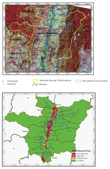
The Upper Pasak river basin has been modeled using MIKE11 software package which developed by the Danish Hydraulic Institute (DHI), Denmark. The built up flood model is simulated flood characteristics of the study area using different weather scenarios. The developed flood model will be adopted for studying an impact of different probabilities of exceedence of rainfall and flow from the North of the study catchment on flood characteristics of the Muang Phetchaboon district. The developed flood model was used to simulate inundation patterns for different flood scenarios. The simulated inundation pattern includes flood extent, depth and duration of flood plain of the Upper Pasak river basin, which particular focus on the Muang Phetchaboon district.
The flood risk maps for flood insurance of rice crop failure were generated using the maximum annual rainfall and streamflow data. The annual maximum rainfall and streamflow data of the rain gauge and river gauge stations located within the study catchment were used to design combined flood hazard scenarios at different return periods. These combined flood hazard scenarios were used to represent the most crucial weather severity at different levels that cause flood in the study area.
For ease of use, flood hazard map should be divided into different distinctly risk zones. The suitable criteria for defining different flood hazard zones of the study area needed to be investigated. This was performed by overlaying the simulated flood maps at the 2-, 5-, 10-, 20-, 50- and 100- year returned periods of each critical flood depth.
From the study it have found that flood extents generated from 2-year combined maximum flood scenarios are separated from flood extents generated from other flood scenarios. The differences between flood extents generated from the 10- to 100-year return periods are very small. Based on these results, flood hazard zones of the Muang Phetchaboon district divided into 4 zones as very high, high, moderate and low flood risk zones.